Swimming Holes and Other Hidden Gems in the Adirondacks
In the Adirondacks, everyone has their favorite swimming spot. For you, it could be a public beach in your hometown, while for others, maybe nothing compares to the crystal clear waters of Lake George. However, if you're interested in trying something different, then you should travel to a swimming hole - a deep spot typically found in a river or stream.
Throughout the Adirondack Park, swimming holes are found in populated areas, such as towns, as well as in more off-the-beaten-path locations. Below, we've provided descriptions and directions for 14 swimming holes and other hidden gems that are perfect for cooling off during the hot summer months.
Hudson River - Lake Luzerne
 The Hudson River flows through the town of Lake Luzerne, and it is commonly used for lazy river tubing in the summer. However, did you know there are also swimming holes in it? North of Rockwell Falls in Lake Luzerne, there are spots where the water is deep enough to take a dip in.
The swimming holes in the Hudson River are found where the river flows alongside River Road. Although they are unmarked, there are a lot of sandbars on the river side of River Road where you can take off and explore the water. Be aware of how close you are to Rockwell Falls though, and don't float or swim too far downstream.
Directions:
- From Cumberland Farms in Lake Luzerne, head north on Route 9N
- Go left onto Bay Road at the traffic light
- Bay Road becomes Main Street, and soon you'll see the sign for River Road
- If you follow River Road up the Hudson River for 3-4 miles, you'll reach the parking area
Hudson River - Warrensburg
In Warrensburg, there is an off-the-beaten-path swimming hole that is great for the whole family. Located in the Hudson River, the swimming hole is a good spot for fishing too.
Directions:
- From Lake George Village, take I-87 north to exit 23 in Warrensburg
- Go through town on Main Street, and turn left onto Adirondack Avenue
- Quickly take another left onto Hudson Street
- Go past the cemetery and Cronin's Golf Resort, and there will be a parking area on the left (the parking area is marked with a DEC sign that says "Lake George Wild Forest - Hudson River Recreational Area"
- Take the trail in the center of the parking lot that goes straight
- Follow it, and you'll end up at a wide trail along the river
- You can head toward the water here, or continue on
- If you want to find the best swimming hole, then take a right on this wide trail
- At the end, you'll reach an old campsite
- Walk through it, and then you can head down a path to flat rocks and the swimming hole
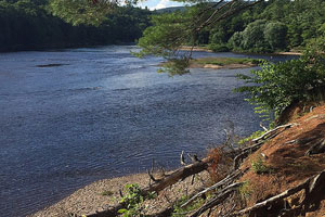
Shelving Rock - Lake George
 In Lake George, the Shelving Rock Area is located on the eastern side. There are two hikes, one to the Shelving Rock Summit, and the other to Shelving Rock Falls. At Shelving Rock Falls, there is a swimming hole where you can cool off after a trek down the trail.
Be Aware: The walk from the trail at the top of Shelving Rock Falls to the bottom where the swimming hole is can be very slippery and steep. Watch your step, and move down the rocky hill slowly.
Directions:
- From Lake George Village, head south on Route 9 until you reach Route 149 on your left
- Follow Route 149 past Route 9L, then turn left onto Buttermilk Falls Road
- At the end of the road, turn left onto Sly Pond Road
- Eventually, Sly Pond Road turns into Shelving Rock Road
- At the end is a New York State parking lot
- Continue down Shelving Rock Road for 2.8 miles and you will reach a steel gate
- From the gate, there is another parking area, and a nearby trail leads to the falls
Mill Creek - Wevertown
Located near the hamlet of Wevertown in Johnsburg, there is a swimming hole in the Mill Creek Recreation Area known as the Black Hole. Despite the ominous name, the Mill Creek swimming hole is actually a great place to cool off. The center is quite deep, but be wary of the depth if you plan to jump in from the small rock cliffs surrounding it.
Directions:
- From Lake George Village, take State Route 9 north and then Route 28 north toward Wevertown
- Along the way, you'll pass the Hudson River at The Glen
- Stay on Route 28 about 2.5 miles past The Glen, then turn east onto Harrington Road
- Travel on Harrington Road for about 1 mile to where it intersects with Mill Creek
- You'll find a pull-off on the right side
- Park there, then travel down a dirt road, cross over a bridge, walk through the park, and soon you'll reach the creek and swimming hole
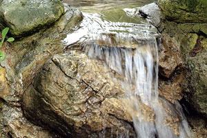
South Fork of the Boquet River
 Just off of exit 30 on I-87 north, there are a few different swimming holes close to a bridge over the Boquet River. However, the best is a medium-sized swimming hole underneath the bridge. There is a trail on the southeast side of the river that passes by several swimming holes in the river. There are some jumping spots as well, but you should always check the depth first.
Photo Credit: The Boquet River Association
Directions:
- If you leave from Lake George Village, head onto I-87 north
- Get off at exit 30 and take Route 9
- Follow Route 9 north to the junction with Route 73
- Head onto Route 73, and after about .3 of a mile, you will pass the South Fork of the Boquet River where there are swimming holes
- However, if you continue on another 1.3 miles to the bridge, the best swimming hole is underneath
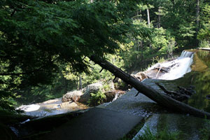
North Fork of the Boquet River
From the swimming spots near the South Fork, if you stay on Route 73, the river will cross under the road once again at the North Fork of the Boquet River. You can park here. On the left side of the road, there will be an unmarked trail at the Five Mountain Loop Trailhead. Follow the trail for .75 of a mile, and then you'll reach Shoe Box Falls. The waterfall descends into a gorge, and the swimming hole is downstream from the falls.
Directions:
- If you leave from Lake George Village, head onto I-87 north
- Get off at exit 30 and take Route 9
- Follow Route 9 north to the junction with Route 73
- Head onto Route 73, and after about .3 of a mile, you will pass the South Fork of the Boquet River
- Stay on Route 73 until the second bridge and park near there
- The Five Mountain Loop Trailhead will be close by
Chapel Pond - Keene
 Over by Giant Mountain and Keene, there is a swimming hole called Chapel Pond. It is the perfect spot to go after a long hike. The site is popular with climbers who use the surrounding cliffs. A beach is available to fish from, and you can launch a canoe or small boat as well. However, the spot does get crowded because it's a less secluded swimming hole.
Directions:
- If you leave from Lake George Village, head onto I-87 north
- Get off at exit 30 and take Route 9
- Follow Route 9 north to the junction with Route 73
- Continue west on Route 73, and Chapel Pond will be on the left
- If you reach the hamlet of St. Huberts, then you've gone just a little too far
Ausable River - Keene
Between Keene and Keene Valley, there is a swimming hole in the Ausable River. From Route 73, across the road from Marcy Field (airport), there is a small park with picnic tables and a swimming hole in the river.
Directions:
- If you leave from Lake George Village, head onto I-87 north
- Get off at exit 30 and take Route 9
- Follow Route 9 north to the junction with Route 73
- Stay on Route 73 through St. Huberts and Keene Valley, and then you can park near Marcy Field
Johns Brook - Keene Valley
 Near Keene Valley, there are swimming holes in Johns Brook, which can be reached from the Johns Brook Trail. Once you enter the trail, you'll be going southeast toward Mt. Marcy. Although it is a loop trail, you should follow these directions if you want to go to the swimming holes.
First, about a half mile in, descend left on a trail that crosses over a creek. Now, you'll be on the Southside Trail. Stay left at the fork, and after 1.3 miles, you'll reach the first few swimming holes. Soon after, there will be even more near Tenderfoot Falls.
Directions:
- If you leave from Lake George Village, head onto I-87 north
- Get off at exit 30 and take Route 9
- Follow Route 9 north to the junction with Route 73
- Once you reach Keene Valley, turn onto Adirondack Street
- Adirondack Street becomes Interbrook Road, and once you reach the end, there will be a parking area and trailhead
Ausable River Dam - Au Sable Forks
Close to Au Sable Forks, there is a dam in the Ausable River. Upstream from the dam, you can swim in the river. West of Au Sable Forks, just off of Ausable Drive, there is a sandy parking area. You can swim in the river, but be aware of the current and how close you are to the dam.
Directions:
- From exit 21 near Lake George Village, head north to exit 34 in Keeseville
- Head south on Route 9N to Au Sable Forks
- Turn onto Country Route 9T
- Follow the road along the Ausable River until you get to the dam
- The swimming spot is upstream from the dam
Covered Bridge - Jay
In the town of Jay, there are swimming holes near a bridge just off Route 9N. A town park was made in 2008, and from there you can access the swimming holes in the Ausable River. There are a lot of rocks and deep swimming holes to choose from.
Directions:
- From the Town of Jay, the swimming holes are right around the corner
- From Route 9N in the center of Jay, head onto Mill Hill Road
- To the right will be a bridge, cross it
- Now you'll be on N. Jay Road, and you can leave your car near the park
- The swimming area is near the park
Ampersand Beach - Saranac Lake
 On the southeastern end of Middle Saranac Lake, there is a beautiful swimming spot called Ampersand Beach. The half-mile long beach features shallow waters that are great for younger kids. The swimming spot is a popular attraction for hikers to stop by after hiking Ampersand Mountain.
Directions:
- From the village of Saranac Lake, take Route 3 west
- After about 8.25 miles, you'll see a parking area for the Ampersand Mountain trailhead
- Follow the trail from the left side of the parking area
- After heading north for a half mile, you'll reach Ampersand Beach
Bluff Island - Saranac Lake
On the backside of Bluff Island on Lower Saranac Lake, there is a small, 10 foot swimming hole. Bluff Island is only accessible by boat/canoe. However, if you make the trip, there are picnic tables and a sandy area to relax on. The spot is popular, so it can get crowded during busier times of the year.
Directions:
- From the village of Saranac Lake, take Route 3 west
- After about 4 miles, you'll reach the state boat launch
- Take off onto the water in your boat and head upriver into Lower Saranac Lake
- Once you enter the lake, Bluff Island will be the large rock face straight ahead
- There is a sandy part on the left side of the island
Cedar River - Indian Lake
 There is a beautiful swimming spot with a small beach and picnic area right by the Cedar River in Indian Lake. At the swimming spot, there is a dead end where you can park your car and then go for a swim in the river. There are rocky and sandy areas around the spot where you can relax as well.
Directions:
- From the heart of Indian Lake, take Pelon Road north by Indian Lake Central School
- When the road splits, go left onto Benton Road
- Follow Benton Road to the end, and you'll reach the swimming hole at Cedar River
Looking for other things to do in the Adirondacks? Try paddling!