The Van Hoevenberg Trail
 Enjoy hiking in the adirondacks? Then you will definitely want to make it to the top of Mount Marcy, highest peak in the Adirondacks and the highest mountain in New York state. The Van Hoevenberg Trail will get you there.The trail starts out flat and fairly easy, but once you get to Marcy Dam it's all uphill from there.
The hike is 7.4 miles and can be completed in one day, but some hikers choose to camp and continue on in the morning. This will make the hike somewhat easier and more enjoyable! The second half of the trail is very steep and mostly bare rock, but once you make it to the top it is that view that will take your breath away!
CAUTION: This hike is rated a level of difficulty of 5 out of 7. Make sure you are capable of completeing the climb before you start out and remember safety first! Get Specifics below and be prepared for your hike.
Trail ID: 61
Mileage & Descriptions Listed Below:
- 0.0: The trail is mostly flat from the trailhead to Marcy Dam with only +180 feet elevation change.
- 0.4: Crosses the Algonquin Brook. At the far side of the wooden bridge, the trail takes a right turn.
- 0.9: Junction with trail #64 (Algonquin Peak Trail). The Van Hoevenberg Trail continues left.
- 1.9: Crosses Marcy Brook and turns right. Here you ascend small pitches to a flat area just before descending to Marcy Dam.
There are camp sites and privy's located on the right side just before descending to Marcy Dam - 2.3: Arrive at Marcy Dam. The trail continues over the dam. Recently the dam has developed a break in it's dam and the water level is several feet lower. At the opposite side of the dam, you will find a backcountry Trail Register. Follow the trail which continues right from this junction.
- 2.4: Approximately 100 yards past the Trail Register, the Van Hoevenberg Trail joins with Trail #68 (Avalanche Pass Trail). Turn left and continue on following the Van Hoevenberg Trail.
- 2.5: The trail crosses the Phelps Brook. Continuing straight another 0.1 miles, the trail crosses Phelps Brook using rock hoping. *Camping can be found by taking the high-water bridge where you will find a herd path straight off the bridge.
- 2.6: The trail crosses the Phelps Brook. The trail now begins climbing steady at a moderate grade.
- 3.0: *Camping can be found on the left side of the trail. There is a single "Camp Here" disk located next to a herd path leading to the tent sites. There is also a privy located in the camp area.
- 3.2: The trail intersects with #62 (Phelps Mountain Trail) which turns left to the summit of Phelps Mountain. Moderate grade.
- 3.5: The trail crosses a wooden bridge and climbs steeply to a junction at 3.6 miles with a ski trail.
- 4.1: From 3.6 miles, the trail is a series of moderate to steep pitches easing off at 4.1 miles. The trail now continues through a series of wet sections at a moderate grade.
- 4.4: The trail now intersects the upper ski trail. Just past Indian Falls the #63 (Indian Falls / Lake Arnold Crossover Trail) junction is found. Turn left to continue on the Van Hoevenberg Trail.
- 5.0: The trail climbs at an easy grade to a level area at 5.0.
- 5.2: The trail descends slightly to reach the 5.2 mile marker then begins a steep climb.
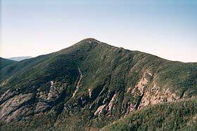
- 5.4: At 5.4 miles, the grade eases off as the trail approaches an open ridge. You now have an open view of Mount Marcy.
- 6.2: Continuing along the ridge, the trail intersects with #2 (Hopkins Trail) from Keene Valley. Bearing right to remain on the Van Hoevenberg Trail.
- 6.5: The trail continues mostly on a flat grade passing the former Hopkins Lean-to site, and then continues on a moderate grade to the former Plateau Lean-to site.
- 6.8: The trail crosses a small stream then passes through scrub to the junction with trail #11 (Phelps Trail).
- 7.0: Continuing right, the trail climbs to some exposed, bare rocks. Crossing over these rocks, the trail dips into a wet area before reaching the shoulder of Marcy.
- 7.4: To reach the summit, the trail now climbs over mostly bare rocks with numerous cairns and Yellow blazes to help you remain on the trail.
Information from highpeaksclimbing.com